The process of creating and expanding urban areas to satisfy community demands is known as urban planning. Both the creation of new land and the redevelopment of existing urban areas fall under the umbrella of urban planning. On the other hand, urban planning has a long history around the world. Concerning this, the remains of ancient towns in South and Central America, Egypt, China, India, and the Mediterranean region provide early examples of urban design.
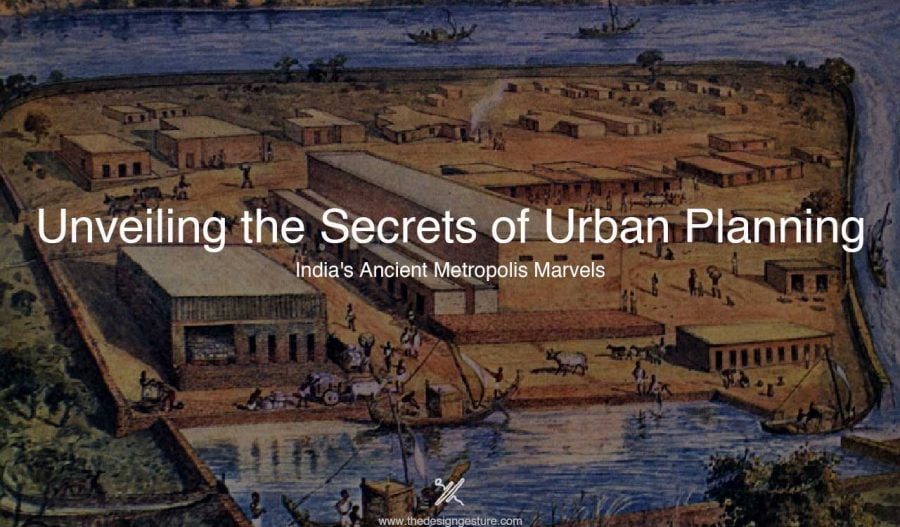
The arranged street patterns in these areas are systematically circular and rectilinear; in addition, public places, including parks, palaces, temples, and government buildings, were taken into account during the design process. Additionally, these cities boasted highly developed drainage and water supply systems, which was quite an accomplishment at the time; Lothal is the most well-known example. The remnants of the evidence are visible in the little cities of that era, demonstrating the significance of planning at the time.
The Indian practice of urban planning dates back thousands of years. The practice of urban planning practice focuses on systematic planning, architecture, quality of infrastructure, and social structure. The town/urban planning during the ancient period was dependent on various factors such as soil type, climatic considerations and conditions, typography, wind, and availability of water in the surroundings.
Table of Contents
Vedic Civilization: Urban Planning of Ancient India
The Vedic civilization can be dated back to 10000 to 3000 B.C. The Indus Valley Civilisation is dated back to 2500 B.C. which is the starting of urban planning in India. Mohenjo-Daro and Harappa are the planned cities of that era. Throughout India’s history, forts and centers of trade and commerce have also given rise to cities and towns. The city was divided in half. Built to protect the upper reaches of the city, it resembled a fort. Maybe the communities’ ruling elite resided in the protected area. Common men resided in the second part of town, which was lower in height than the first. The principal roads in the Indus Valley met at right angles and traveled from east to west and north to south.
The width of the roads varied from 9 to 34 feet. They ran nonstop for a mile. They were appropriate for transporting on wheels. Streets were linked to lanes. In every lane was a public square. One distinctive aspect of the society was its intricate drainage system. Magnificent brick piers, warehouses, granaries, dockyards, and fortifications could be found in the cities. The city was protected from invaders and floods by enormous citadels. Most residents of cities were craftsmen and traders.
The classification of the town was done based on the Vastu Shastra, mentioned in the sacred and ancient texts of Indian Literature. Classification can be observed as,
Dandaka
During the ancient period, various designs and shapes were used to symbolize different things, promoting various built environments, dandaka is referred to as rod shape planning.
The towns were planned on straight lines and regularity, symbolizing stability and order. The towns are supposed to be rectangular and located in the eastern direction. Here, female deities are homed outside the town while male deity in the northern direction. The ultimate practice.
Sarvathobadra
The circular form and radiating roadways in this town design give the built environment a sense of balance and harmony. The primary purpose of the Sarvathobadra designs is to create areas of religion and spirituality that encompass the entire town or hamlet.
Nanydyavarta
This circular layout features streets extending outward from a center square. mostly due to the huge payment. The plan represents wholeness and coherence. The idea that the plan exudes positivity was a conviction.
Padmaka
It is a Sanskrit word meaning town with a lotus shape. Lotus flowers have been said to represent purity, enlightenment, and beauty since ancient times. mostly for places of worship and spirituality where people went to find solace and tranquillity. This plan emits positive energy, just like other plans do. The petaled streets enhance the visual appeal.
Image Source: https://archi-monarch.com/town-planning-principles-in-ancient-india/
Swastika
The Sanskrit term “swastika” means “good fortune” and “well-being.” Swastik is frequently utilized in Hindu houses and temples as a decorative element. Planning based on the Swastika symbolized the entrance in the past, signifying Hinduism’s belief in the cyclical nature of existence.
The layout featured diagonal streets that split up into triangle-shaped areas. There is a rampart wall all around the town. The temple serves as the overall center.
Prastara
It is the term that refers to the arrangement of tile or stones used in the floor or pavement construction. In ancient times, the Prastara was an important decorative element that was used to create intricate and beautiful patterns on floors.
The plan is square or rectangular not triangle or circle. Site size increases based on the financial capabilities of the buyer or the owner. The town is not surrounded by a fort or wall. The town had wider streets.
Karmuka
The strategy is like a bow. The plan is better suited for semi-circular or parabolic locations situated along riverbanks. In these locations, the major thoroughfares run directly from north to south or from east to west, intersecting at a right angle.
Chatmurkha
The structure with four faces and entrances is referred to by this word. These buildings fulfilled a variety of functions, including those of temples, gates, and secular or religious constructions. The four orientations are represented by the four façades.
That is thought to be done to shield the buildings from all sides. Additionally facilitating the simple movement of people and products into and out of the building, these four facades and entrances enhanced accessibility and connectedness.
The location should have four faces and be either square or rectangular. With four main streets, the town is laid out in an east-west pattern. There is always a temple at the center.
Medieval Period: Transition in Urban Planning Strategics in India
In India, the medieval era was a time of transition, and systematic and planned urban growth was not feasible due to unstable political circumstances. In multiple towns, fortifications were constructed. Buddhism has a significant influence on architecture and development. The renowned urban planning treatise “Arthashastra.” It listed the following attributes: zoning laws based on the community. The excavation in the capital of Magadha (now Bihar), Patliputra, shows a high level of planning proficiency. Taksha-sila and the renowned learning center Nalanda were established during this period.
Medieval towns were surrounded by a moat and were classified based on classes and the control was observed too. Additionally, the Mughals adopted the notions of Vaastu Shastra, the rectilinear forms and patterns of urban planning too. The Industrial Revolution after the British invasion of India also affected the planning. Railway was introduced which led to rapid urbanisation. Additionally, Underground water supply and sewage were also included in the planning.
However, after independence, India has seen great progress in planning to build a sustainable place.


