Table of Contents
Background
Ahmedabad was founded in the 15th century and is the largest city in the state of Gujarat. It is located in the strategic Delhi Mumbai Industrial Corridor (DMIC), which offers great potential for investment, industrialization, and urban development. The Ahmedabad Municipal Transport Service (AMTS) was established in 1947 as one of the first urban transport organizations in the country. In 2005, the AMTS bus fleet had been reduced to 521 buses and the daily number of passengers had been reduced to 390,000 and the total share of the public transportation system in Ahmedabad was 15%.
The city is a vibrant business district and an emerging center for education, information technology, and the scientific industry. According to the 2011 census, it has 5.5 million inhabitants in the municipal limits and 6.3 million in the urban agglomeration.
With the decline in the number of public transportation passengers, the city experienced rapid growth in ownership of private vehicles, particularly two-wheelers. Rising gross domestic product (GDP), coupled with rapidly increasing vehicle ownership, prompted city authorities to explore ways to reverse the decline in the modal share of transit-oriented development in Ahmedabad.
Given the growing dissatisfaction among commuters due to the low level of service and lack of comfort on AMTS buses, the authorities have introduced a high-quality transit-oriented development in Ahmedabad; as Janmarg BRTS; as part of the JnNURM program in 2005. The goal of BRTS was to create spaces on the streets for pedestrians, bicyclists, and vendors, and manage street parking.
Janmarg- Bus Rapid Transit System
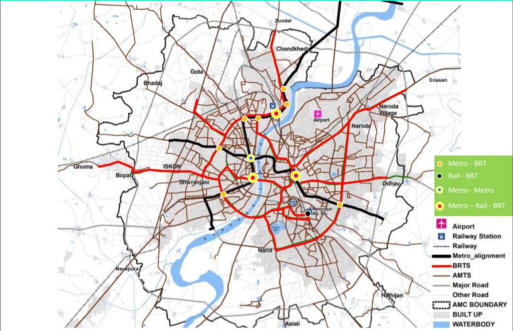
The BRTS system in transit-oriented development in Ahmedabad is called Janmarg and is operated by Ahmedabad Janmarg Limited (AJL), a subsidiary of Ahmedabad Municipal Corporation. The project was initially carried out in 2 phases and the execution of the third phase was subsequently approved in 2013.
Phase 1 passed ran over a distance of 12.5 km, opened to the public in 2009. The second phase had to be completed in 2010 and covers 84 km with an additional 4 km of elevated corridors, but was not completed until 2014. The third phase is currently underway. Constant efforts have been made by Ahmedabad Janmarg Ltd. to update the system and make it more efficient.
AJL uses smart cards for tickets and the intelligent transport system; to improve customer convenience, speed, reliability, and security of the bus system. It is widely used in the areas of operational control, electronic fare registration, real-time passenger information systems, and traffic management (Center of Excellence in Urban Transportation, 2010) in the BRTS system. BRTS is designed to connect recreation zones, education zones, and other important areas along the corridors.
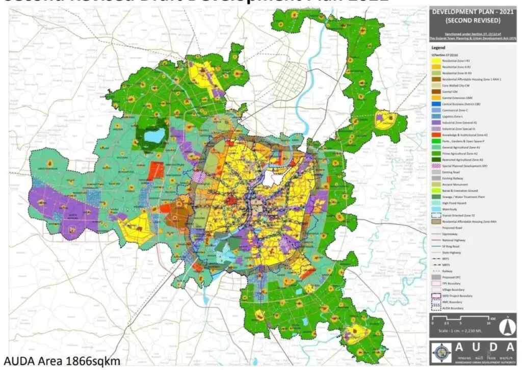
The BRT network has also triggered the redevelopment of these areas with more built-up areas next to the corridors. The BRTS corridor impacts the city’s land use and housing policy, particularly in the context of the Development Plan. A new residential area with an emphasis on affordable housing has been proposed along the Sardar Patel bypass road.
Components of Transit-oriented Development in Ahmedabad
Public Transportation System
Ahmedabad’s practice of local zoning through town planning has resulted in a fairly dense road network throughout the city.
Connectivity and Network Density
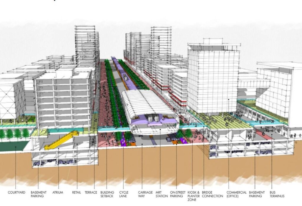
Increase the width of the traffic-oriented zone to 400 m on each side of the BRT corridors and a 400 m radius around the metro stations to reflect this 5-minute walk to these public transports. This will allow more of the expected growth to occur in proximity to existing S-Bahn lines.
Off street and on street parking
Minimum parking requirements should be significantly lowered for all land uses in all traffic-oriented zones, not just commercial land uses along BRT corridors, in order to promote the use of public transportation. This provision will reduce urban development costs in transit areas.
Detached parking lots, if created, should be located outside the 400m pedestrian buffer zone of public transport stops to reduce congestion and facilitate pedestrian access in these areas. Such off-street parking should be financed through private investment rather than government funding. The only exception to this rule is the creation of bicycle parking spaces within the transit zone. The total parking space in each area on the street, as well as off the street, should be limited to the carrying capacity of the street network.
Factors of Public Transportation System
Land use
The core of the Ahmedabad metropolitan area is dominated by commercial areas, mixed land use, and large residential areas along the periphery. In the immediate vicinity of the residential areas within the boundary of the city administration, there are several properties under the industrial area.
This urban settlement structure and workplace location have triggered a traffic pattern with regular movements in both directions, from the periphery to the city center and vice versa, throughout the day. Land use along the BRTS corridor has changed over time. The increase in a built-up area and urban skyline can be clearly seen along the BRTS corridor, as more “ground + 5” structures were built.
Housing
Approximately 13.5% of the total population of AMC lives in the slums of Ahmedabad. Although the number of slums decreased by 40% in 2014 compared to 2011 around 0.16 million households still live in the 961 slums of the city. In order to remedy this situation, AMC & AUDA have proposed the construction of affordable homes with an average constructed area of between 30 and 60 m².
AMC expanded the city limits due to land limitations and proposed resettlement areas along the periphery of the city. These areas were the zones of reception for urban development programs. The BRT has expanded the connection to these areas on the outskirts of the city, thus offering residents affordable means of transportation. In the future, integrating the transport network with these residential clusters is one of the fundamental goals of the development plan of Ahmedabad for 2021.
Density
Identified special zones along the BRTS and proposed metro corridors will have higher allowable FSIs. The different FSI in the city ranges from the highest value of 5.4 in CDB, 4.0 in transit corridors, and 1.8 (with FSI based on fares up to 2.25) in other parts of the city. It is proposed to implement a 4.0 FSI on a 41 km long route within TOZ.
Diversity
The distribution of land use within the impact zone remained flexible and is characterized by mixed uses. However, it is imperative that the areas marked under the zone of influence do not have separate land uses and unidirectional zones.
Conclusion
Before BRTS, AMTS had 7,500 passengers per day entering and exiting the corridor, which increased to 17,500 passengers per day in the first week of BRTS operations by adding 10,000 passengers per day (Center of Excellence in Urban Transportation, 2009). However, the ability of BRTS to bring about a radical shift from private to transit-oriented development is not yet evident. So far there has been a shift of around 8% to the public transportation system, mainly from two-wheelers. User experience suggests that the BRT system has not yet reached the outskirts and inner areas of the city.
Currently, commuters in the city from outside the city limits can only use the BRT at certain stops in the BRT corridors. This has caused people to use private transportation, such as motorcycles and scooters, to enter the BRT corridors. The BRT system has yet to improve full traffic integration to provide end-to-end connectivity between work and home/origin. In addition, the proposal to expand the BRT to the eastern part of the city represents a challenge for the city authorities to ease and cope with the existing high density in the area.


